


Jacksons Drones
Multispectral Sprouting Corn Dataset - 350ft AGL - Mavic 3 Multispectral
Regular price
$14.99
Multispectral Sprouting Corn Dataset - 350ft AGL - Mavic 3 Multispectral
Regular price
$14.99
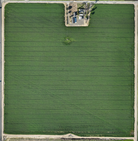
Description
Purchase this Central Valley Fruit Tree Photogrammetry Dataset, captured from an altitude of 350 feet above ground level (AGL) using the DJI Mavic 3 Multispectral Drone.
This comprehensive dataset is designed be a Medium quality drone dataset for use in precision agriculture. This data can be used to photogrammetry processing, machine learning, Education or Marketing purposes.
indispensable resource for agricultural analysis, environmental monitoring, and spatial research.
Data collection parameters:
- Captured at 350ft AGL.
- 80/70 Nadar grid pattern.
- Multispectral and Visual files included.
Included:
- Image Files
- Multispectral Calibration data.
- Ground truthing photos.
Instant Download .Zip download Upon Purchase.
Collapsible content
Provide your customers with additional information about the product.
Collapsible content
Provide your customers with additional information about the product.